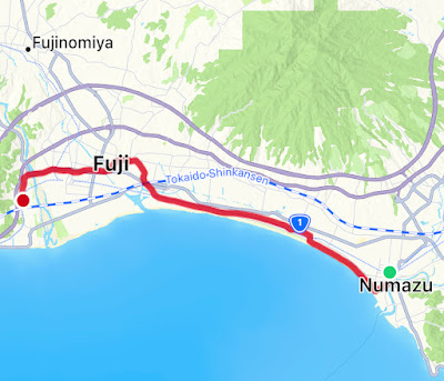
The day did not begin well. Overnight, gout had flared up in my right ankle, and I had serious doubts as to whether I’d be able to walk more than a kilometre or two. Figuring that any progress was better than none, from the hotel in Shizuoka I caught the Shinkansen and a local train back to Numazu and picked up the route.
And here a confession: at first, I didn’t follow the exact route of the Old Tokaido. One of the things Numazu is well known for is Sembonmatsubara, which means Thousand Pines. It’s a long, thin strip of pine forest just behind the shore, running parallel to the OT for several kilometres. As that involved walking slightly further than I would have on the OT, my conscience is clear. A track meanders gently through the trees, and in the low sun of early morning with very few other walkers about, it was a very pleasant place to be.
My ankle wasn’t getting any worse, and in fact after a few kilometres started gradually easing. The path was flat, compressed earth and mostly level, so an ideal surface.
I passed a rare example of Japanese graffiti:
Hara, the next post town along on the OT, is apparently the closest of all 53 to Mount Fuji, a fact noted just outside the little rail station with another Hiroshige reproduction:
I’d made the short detour to the station in search of refreshment and somewhere to rest, neither of which I found. A little further on, though, I passed a shop with a handwritten sign in English: “Amayuki I made myself. 200 yen.” That had to be better than something from a vending machine. It turned out that the shop mostly sold bottles of amayuki, which is a traditional fermented but non-alcoholic drink similar to the amazake I’d had at the chaya near Hakone Checkpoint a couple of days ago. After the usual apologies for my lack of Japanese, I managed to explain that I just wanted a cup to drink now. Unlike the amazake, this was served chilled, but it was just as delicious and equally refreshing. The owner asked where I was from, and after showing her my introduction she was kind enough to let me take her photo posing with a bottle.
We exchanged a few words about how beautiful Mount Fuji looked, she handed me a leaflet in English about her business, Hasuin-Masamune, and I set off, much revived. I was half a kilometre down the road before I realised I’d forgotten to ask her name. I’m so sorry.
The views of Fuji were indeed stunning. In built-up areas it’s often hard to get a shot that doesn’t include a lacing of overhead lines. This was the best I could do.
A little further on I crossed into Fuji City, which makes the most of the obvious association on signs…
… and manhole covers:
Near Yoshiwara rail station the OT takes a big loop inland. There’s little of interest for the modern traveller on this long section of the walk. In the past, one stretch of road where the OT heads slightly east of north was famous for being the only place where (when heading from Edo to Kyoto) Fuji appeared on the left. That view has long gone, but is commemorated by a stone tablet with the inevitable Hiroshige reproduction (you can just make out Mount Fuji to the left of the foreground tree)…
Near Yunoki rail station I noticed an ad for the G’day English School, and amused myself for a while with thoughts of hundreds of Japanese children being taught broad Australian vernacular.
“English conversation. Monthly fee system from three years old to adult.” Maaaate.
At last I reached the long bridge over the Fuji River as the sun set behind the hills on the far side.
The OT carries on onto the lower slope of those hills, through what looked like a really pleasant neighbourhood but a) it was dark and b) I was too tired to care much. The busy road was narrow, winding and dimly lit, and I was glad of the front and back lights of my head torch to provide some protection.
Eventually I wound back down the slope and into Fujikawa station, from where I caught a crowded train back to Shizuoka and a very, very welcoming bed. I knew this was going to be one of my longer days on the Old Tokaido. I hadn’t reckoned on it being this long.


What a long day! I’m loving the daily recaps 😃. Well done John, maaate!
ReplyDeleteThanks Ying!
Delete