
Slightly warmer again today, although with a haze that obscured the more distant views.
I again took advantage of the hotel’s free breakfast before jumping on a Tokaido local train one stop down the line to Takatsuka.
Not far down the road, a large shrine provided an opportunity to pay my respects and hope for a successful day’s walking.

There was little of interest between Takatsuka and Lake Hamana, although it was good – as always – to come across an avenue of typical Old Tokaido pines:

I stopped for a takeaway coffee from a konbini and spotted a park opposite that offered shade and benches. It turned out to be the grounds of a shrine, hidden amongst the trees, but as a group of seniors was setting up for a game of that golf-croquet hybrid I’d seen a few days earlier, I figured recreation was just as valid as devotion in this particular spot. A woman parked her bicycle near my bench and spoke to me; I adopted the default position of smiling and nodding, and gesturing to indicate there was plenty of space on the bench. She produced a pack of tissues and started wiping it down – an effort that seemed to have no effect on the cleanliness of the rather grubby bench. Coffee finished, I said thank you very much, bowed and continued on my way.
At the point where the OT crosses a main road, near Maisaka station, a jolly drummer watches over traffic. According to the plaque below, it relates to the story of a “jet-black boy” living at the bottom of the sea caught by local fishermen. They threatened to kill him, but he promised to warn them of imminent dangerous weather by beating his drum. So they returned him to the sea, and now, “it is said that when the weather changes, the sound of waves [the drum?] can be heard”.

Another nearby plaque explains that once upon a time, the Tokaido ended here – or at least this section did. Ahead is Lake Hamana, and travellers would take a ferry a couple of kilometres across to Arai. Nowadays you can walk all the way, across bridges and what I assume are artificial islands, and the ferry, sadly, no longer operates.
This shot was taken looking back up the road (eastwards) from here:

The sign also explains that Lake Hamana used to be a freshwater lake, but an earthquake in 1498 created a breach in the land between the lake and the sea, and it’s now tidal.
Down at the waterfront, a number of these old lanterns have been preserved or reconstructed:

… and there’s a great view of a ‘floating’ torii (at low tide, obviously firmly anchored in one of the lake’s sandbars):

(Just to the right of the torii you can see a wind turbine on top of the hill. I would be heading up that hill and passing the turbine later.)
At Arai, on the west side of the lake, the Tokaido ‘barrier’ or gate has been reconstructed:

Apparently it was open from 6am to 6pm.
Here the Old Tokaido takes a sharp left turn and heads south for a couple of kilometres before swinging west again. The less said about that stretch of the route, the better. The only thing of note along here were these three identical apartment buildings, imaginatively named Matsuyama A, B and C:

Finally that section ended, and just before the road I was on joined a major road, the OT swings north and heads up into those hills spotted earlier from the other side of the lake. This is, in fact, one of the major inflection points on the Tokaido: this is as far south as it goes, and from here it heads decisively north-west around Mikawa Bay and towards the metropolis of Nagoya. A photo seemed appropriate (I’m heading towards Futagawa).

The rise that heads up from this signpost isn’t all that long, but it’s pretty steep, and was often the subject of popular artworks including (inevitably) this one by Hiroshige, reproduced on a sign halfway up:

The top of the hill was famous as the spot from where travellers from Kyoto could get their first glimpse of both the Pacific Ocean and Mount Fuji. Fuji-san was hidden behind haze today, but there was a nice view of the glittering ocean:

From the top of the hill, the route wound gently down towards the Sakai River (little more than a stream) and, although I didn’t realise it at the time, the border between Shizuoka prefecture – which I’ve been in since way back at Hakone Pass – and Aichi prefecture.
Sights along here included a distinctive approach to roadside garden ornamentation:

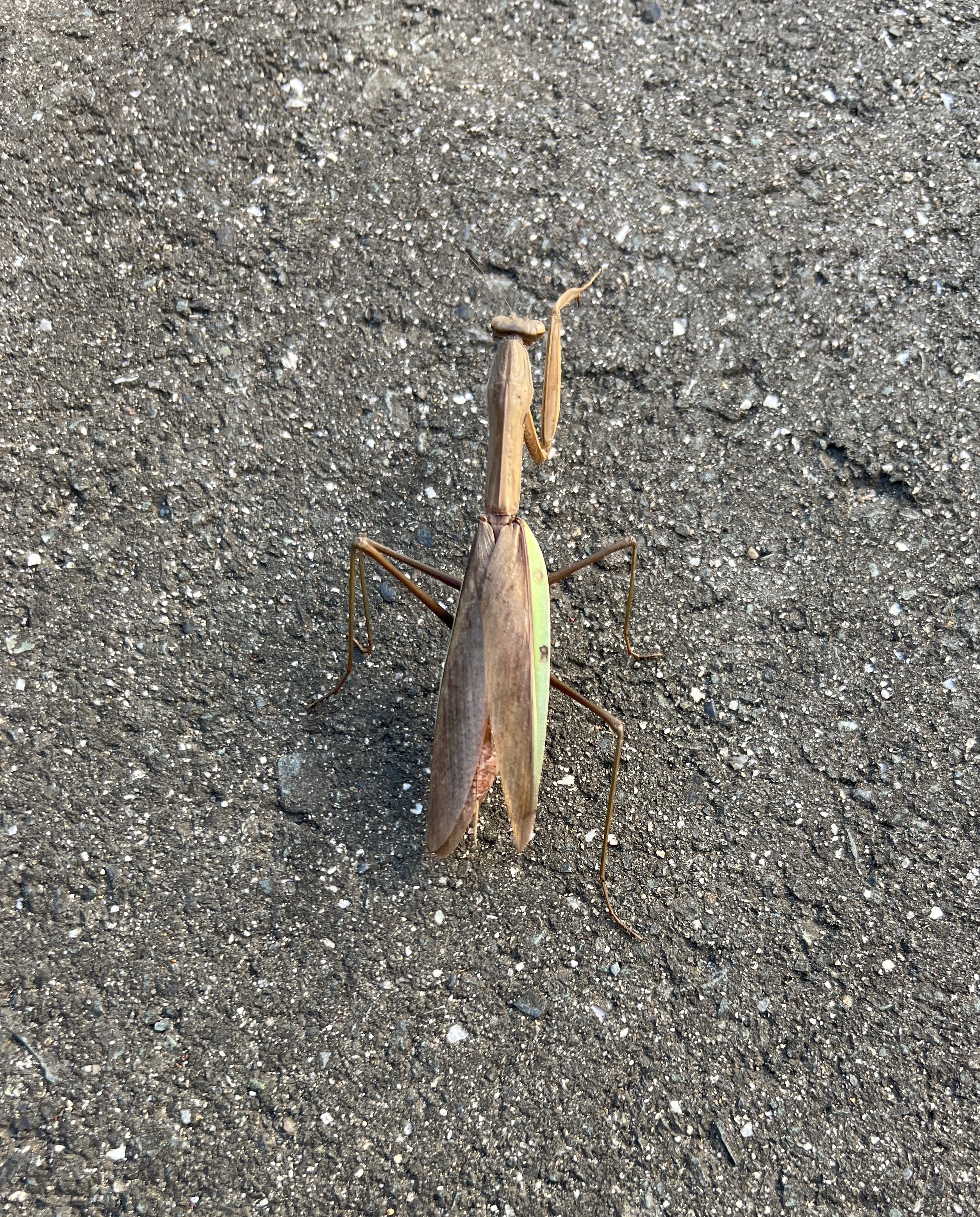
… and a large stick insect that I just avoided treading on:
Near a junction with a busy road, a Buddha (?) watches over a field of cabbages:

There are a lot of cabbages grown around here.
Having rejoined Route 1 at this point, it was just a long, boring and slightly unpleasant gentle downhill slog to Futagawa, with cars and trucks flying past through an industrial-rural interface landscape. At least I had the distance markers to remind me how far I’d come from Nihombashi:

So it was a huge relief to eventually reach the outskirts of Futagawa and turn off the main road, under the Shinkansen tracks, over the Tokaido main line tracks and into the well-maintained back streets of this former post town. A sign with a good English translation gave the history of the town and an explanation of the different classes of lodging for different classes of guest:

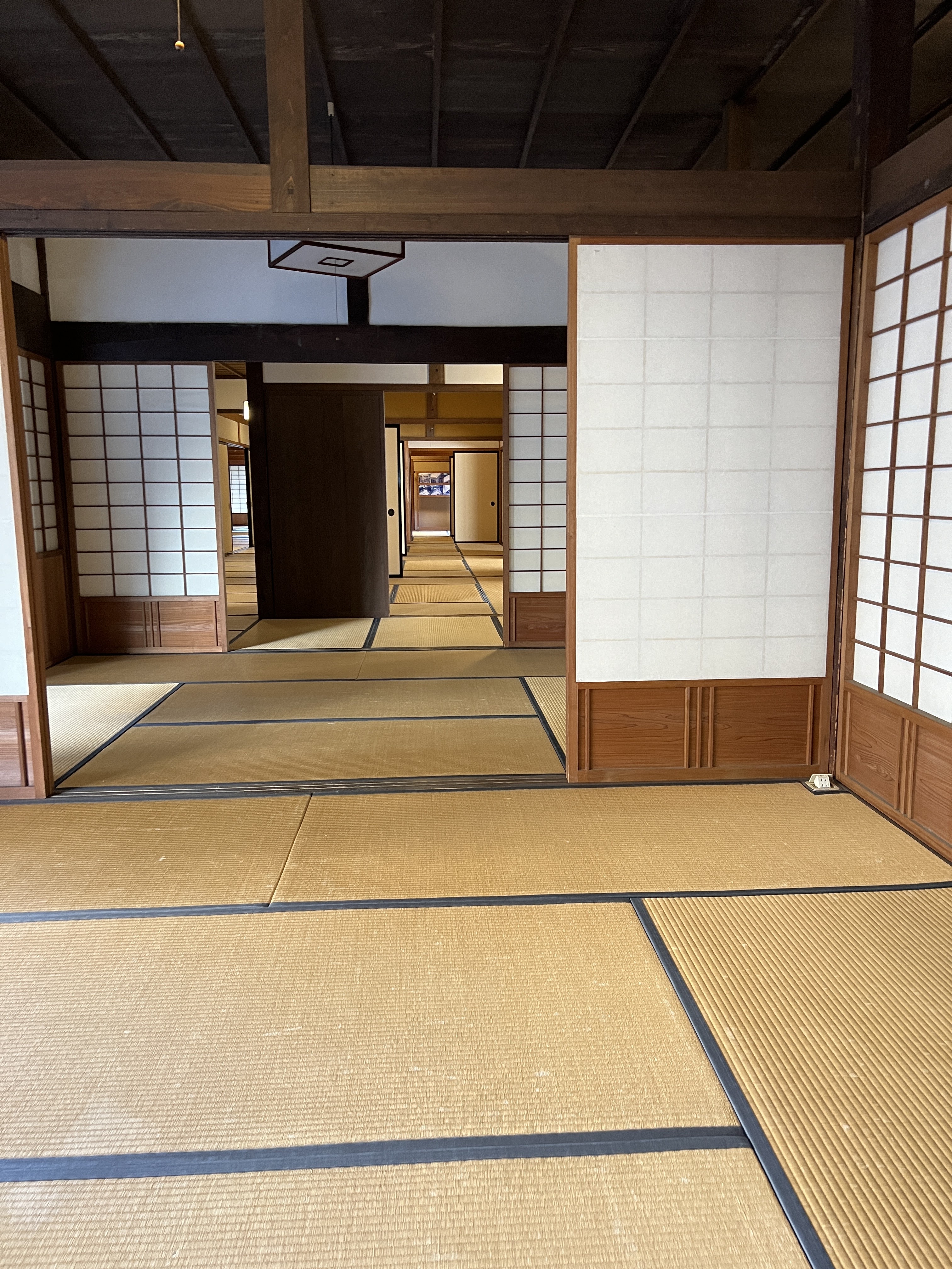
The restored honjin mentioned on the sign was well worth the 400 yen admission. Features included a palanquin in which high-ranking travellers would be carried:

… a series of tatami-floored rooms with traditional sliding screens:
… views of a tiny courtyard garden …

… and main entrance:

… and the official function room:

There was even a room to play dress-ups in traditional clothing, including various old-style hairdos. I’m not sure this one really suits…

From the ridiculous to the sublime: late-afternoon sun highlights a spark of autumn colour in one of the honjin’s gardens:

From the honjin it was another kilometre or so to Futagawa station, from where I took a local train onward one stop to Toyohashi, transferred to the Shinkansen and then rocketed back to Hamamatsu and the hotel.
That was the fifth consecutive day of walking, and to be honest it was one day too many. From the halfway point onwards, fatigue meant it was more of a slog than a pleasure. It’s great to be about 15km further than I’d planned at this point, but to avoid the remainder of this walk become an ordeal I definitely need to have a rest day every fifth day. As that’s what my original itinerary was based on from this point onwards, I’m still reasonably positive about the prospect of arriving in Kyoto on schedule on 7 December.
Comments
Post a Comment