Tokaido Day 19 – Monday, 27 November: Shin-Anjo to Atsuta (30 km)


I caught a train back to Shin-Anjo, where arriving passengers transferred into lines for buses bearing names like Mitsubishi and Denlo. Toyota City (named after the car maker, not the other way around) is not far from here, and I guess this area is one of the major centres of Japan’s auto industry.

I, of course,  was relying on a much slower form of transport, and soon came across a nice little shrine half-hidden in a grove of trees, where I paid my respects.


Approaching the Tokaido post town of Chiryu, a pine stood atop an ichirizuka.


A nearby sign explained that an avenue of pines used to stretch for nearly a kilometre, but that housing development has halved the length. A typhoon wrought further destruction in 1952, but in 1971 about 150 new pines were planted and the local authorities work hard to protect the remaining trees.

A pine also features in one of Hiroshige’s prints of the Tokaido stations, which depicts the annual horse fair for which Chiryu was famed for hundreds of years. Of course there’s a roadside reproduction.


The Tokaido makes a left and right turn at the western end of Chiryu, and a park in the angle of the bend offered a spot to have a rest and a couple of mandarins I’d bought from a supermarket yesterday. As I was tidying up and preparing to leave, I noticed an old man who’d appeared on a nearby bench, having a cigarette and smiling in my direction. I bowed and said “konnichiwa”, and he asked me a question. As usual, I apologised for my lack of Japanese and showed him my written introduction. As others have done, he expressed surprise and admiration for the endeavour, and we chatted as best we could. 

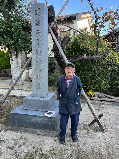
I asked if he would mind writing his name in my notebook, at which point my pen stopped working and he went into what was obviously his house just behind the park, returning with a box of pens – of which he gave me one as a gift. Functional writing implement secured, he wrote his name in both Hiragana and Romaji, and very kindly agreed to let me take his photograph:


Yoshihiko-san told me he’s 90 years old, but he could easily pass for 10 years younger.

We said our goodbyes, and I turned the corner of the road to find a shop filled with interesting-looking pottery. Peering in the door, who should appear at the back of the shop but Yoshihiko-san. “My home!” he called in English.


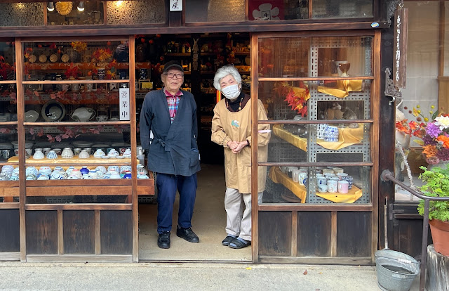
I could have bought half a dozen things, but was conscious of the weight and fragility of the items over what would probably be another 20 km of walking today. In the end I settled on just one, for a Christmas present. As I handed over the money, he invited me into the back of the shop, pointed to a cushion and in an instant produced a pot of green tea and a cup. The tea was delicious, and I was enjoying it while Yoshihiko-san pottered about in the shop when Yoshiko-san, his wife, appeared (I obviously looked confused at the similarity of the names, as they laughed and assured me I’d understood them properly). Yoshihiko-san explained who I was, where I was from and what I was doing, and his wife produced a bag of mandarins to help me on my way. Pen, tea, mandarins … these little moments of spontaneous generosity are  so touching.

There were many smiles and much laughter as we did our best to communicate in Japanese, English, sign language and (when all else failed) Google Translate. But eventually I had to be on my way, and I am delighted to say that I was able to photograph them both in the doorway of their shop.


The next 8 km or so were of little interest. The Tokaido wove in and out of Route 1 through an industrial landscape dominated by the auto industry. With few options for lunch, I plucked up my courage and opened the door to a ramen shop – which fortunately turned out to have one of those machines at the front where you place your order (with helpful pictures) and pay, and then hand the ticket to someone behind the serving counter.

The restaurant was on a little sliver of land between two busy roads, with a freeway overpass just behind, and the clientele were almost entirely men in boiler suits from nearby car yards. This was about as far from tourist-trail Japan as you could get.


But the ramen was delicious, and I felt fully re-energised as I set off again.


Things got more interesting when I reached the district of Arimatsu, which is famous for having preserved its Edo-era streetscape and for traditional tie-dying techniques, of which I think it’s the leading centre in Japan. Most of the businesses on the Tokaido street frontage feature the town’s name in Hiragana on tie-dyed noren curtains.


I stopped in at a shop and bought a traveller’s hand cloth (essential in Japan, as many public bathrooms don’t have hand drying facilities), but I can’t help thinking someone with a better appreciation of textiles and related matters would have got more out of the town than I did. The street was lovely, though.


(That’s a freeway overpass in the background, by the way.)

Update: You can learn more about shibori, the traditional tie-dyeing techniques of Arimatsu, here.

This is the hand cloth I bought:


Across the Tenpakugawa (Tenpaku River River, according to the sign)…


… to find an ichirizuka with the biggest tree on top yet.


At first I thought it was a type of fig, but Apple’s plant ID tells me it’s a Chinese hackberry. That fits, as several signs along the Tokaido have mentioned hackberries as being a common choice for ichirizuka. Now I know what one looks like.

At Kasadera, a large and particularly beautiful temple was entered via a stone bridge and the traditional gate house …


… and then up a modern ramp to the main temple building itself.


The photos really don’t do justice to the beauty of the place. By now it was late afternoon and what had started as a sunny day had clouded over. In other words, I’m blaming the light rather than my lack of photographic skills.

Nearing the end of the day’s walk, I navigated a multi-lane city highway via a pedestrian bridge, with an elevated expressway above the whole lot. There’s something magnificent about the ugliness of the scene.


And so finally to the end, in more ways than one. Atsuta was where the Tokaido land route stopped, temporarily. Travellers heading to Kyoto would take a ferry from here, across the head of Ise Bay to Kuwana, where they would pick up the trail again. Several large rivers flow into the bay around what’s now the city of Nagoya, and until relatively recently a ferry was by far the quicker and easier option. The distance over water between Atsuta and Kuwana was about 28 km, or seven ri, so the station at Atsuta became known as Shichiri-no-Watashi, or Seven-ri Ferry.


This was the night light that used to guide ferries to shore.

From Atsuta, it was a short walk and subway ride back to Kanayama and my hotel. At which point, two realisations:

1) I’m a whole day ahead of schedule. My original plan had me arriving at Atsuta tomorrow evening.
2) Because Old Tokaido travellers had the relative luxury of a ferry ride from Atsuta to Kuwana (the ferry unfortunately no longer runs), it’s become customary for modern Tokaido hikers to similarly give themselves a break from walking and use public transport to hop on to Kuwana. I hadn’t factored that into my original itinerary, and seeing as Kuwana was where I’d planned to end up the day after tomorrow, that means I’m actually two days ahead of schedule.

Although I could slow down and aim to arrive in Kyoto on 7 December as originally planned, my inclination at the moment is to press on and get there a couple of days early, giving me more time for more leisurely sightseeing between the end of the trek and the return to Sydney – and perhaps allowing me to get a little further afield than originally seemed possible.

It feels good to have options.


Comments

Popular posts from this blog

Tokaido prologue

Hiroshige, Fifty-three Stations of the Tokaido . No. 26: Kakegawa I visited Japan in 2017 and 2019, on the second occasion with Fred, as well as my partner (with whom I’d travelled in 2017) and her son. Like most people who come for the first (or second) time, we took the Shinkansen – bullet train – from Tokyo to Kyoto on the line called the Tokaido. Volumes have been written about the wonders of Japan’s Shinkansen system. It is, I think, something that should be experienced at least once in everyone’s life if possible. ‘Tokaido’ means ‘eastern sea road’, and the line bears that name because it follows – more or less – the route of the centuries-old road that linked the Imperial capital of Kyoto with the Shogunate’s headquarters in Edo (now Tokyo), respectively the seats of ceremonial and administrative power. For hundreds of years, thousands of travellers made the 500-kilometre trip between the two cities (and usually back again), the vast majority of them on foot: horses were rare, t...

Tokaido Day 1 – Thursday, 9 November: Nihombashi to Kawasaki (22 km)

Link to GPS track Any sense of excitement at the dawn of the day that I would actually start this thing I’d been planning for so long was somewhat subsumed by the need to organise my gear and arrange for stuff I wouldn’t need for a couple of days to be sent on to the next hotel. The front desk staff at the Hotel Sunroute in Asakusa were, of course, extremely helpful and told me that the bag would arrive at the Terminal Hotel in Odawarra the next day. That still left me with a pack that was heavier than I’d been expecting – I guess about 15 kg – and it was with a slight sense of trepidation that I checked out and headed to the subway to catch the Ginza line to Nihombashi.  Nihombashi – which I think just means ‘Japan bridge’ – marks the start of the Tokaido and is traditionally the place from which all distances to Tokyo are measured. Today its historical significance is not immediately apparent, not least because of the dominating freeway overpass that crosses above. However, the c...

Tokaido Day 13 – Tuesday, 21st November: Kanaya to Fukuroi (29km)

  A more overcast and humid day, but still good conditions for walking. My hotel offers a free buffet breakfast, which I couldn’t pass up, so by the time I caught the train from Hamamatsu back to Kanaya I was a little later than previous mornings. No matter.  From the station, the Old Tokaido climbed steeply, and it wasn’t long before I encountered another section of the dreaded ishidatami. Although just as steep as the section near Hakone, this was in better condition and nowhere near as long. Still, it’s not easy walking, and once again I was glad of the pole. I agree with the Temple Guy : this is much harder than Satta Pass, and I’m surprised it doesn’t have more of a reputation on the walk. Once the ishidatami ends, there’s still plenty of hill to climb, and the route rises through tea plantations. On those grey poles are electric fans: I’ve read that they’re used on still, humid mornings to blow away the mist that could otherwise damage the leaves. Where the bushes are in...