Aiming to continue my pretentiously and only recently named Great West Trek, I caught the train to Warrimoo and started walking. Actually, I walked to the B-Line bus stop in Mona Vale, caught the B-Line to Wynyard, hopped on a suburban train to Central and then caught the train to Warrimoo. The result of all this faffing around was that I didn't start walking until nearly 10am, which had implications for later on in the day...
There was little of interest to note in the first 5 km or so. I was following the old highway, parallel to the modern main road and usually far enough away to be pretty quiet. This being late winter, flowers provided some scenery along the route, even if not all the blooms were natives.
Just past Valley Heights station, a small fire burned on the embankment, producing a little smoke and no visible flame. Unsure if this was someone burning off a bit of garden waste (tut tut) or something potentially more serious, I paid it little attention. That half-formed question was answered 10 minutes later on the outskirts of Springwood, when the fire truck flashed past heading (presumably) for the unauthorised burn. Can't be too careful round here, I suppose, even on a mild late winter day.
Soon I was entering Springwood itself on a road I know well, seeing it for the first time on foot. The town centre was busy, and although I half expected to bump into Leo or Adrienne, I made it through the shops and out the other side without human interaction.
Just past the commercial centre, a man was using an electric blower to clear ghastly, unsightly fallen leaves from a front yard in which a derelict car sat rusting conspicuously, ensuring aesthetic priorities were maintained.
By the time I reached Faulconbridge, the siren song of the egg sandwich in my backpack had become irresistible. Fortunately, Faulconbridge is also the location of the Corridor of Oaks, which commemorates many (but not all) of Australia's prime ministers, and is thoughtfully provided with a selection of benches to rest the legs of the weary traveller.
It's a very pleasant spot and an interesting project, although the layout is a little confusing. Starting at one end of the corridor the PMs seem to be arranged chronologically either side of the boardwalk. Of the ones that have overlapped my time in Australia, there's Bob Hawke, then Paul Keating ... and then Julia Gillard. Our first female prime minister is certainly worthy of a planting of her own, but – regardless of what you think of him – the absence of Howard (not to mention Kevin Rudd) seemed odd. I soon discovered that some of the other PMs were commemorated out of sequence on the other side of the central sandstone paved area, including Howard and Rudd. There was, however, no one more recent than Gillard – perhaps, given the number of prime ministers in recent years, the organisers of the project are worried about running out of space.
At Faulconbridge station the route crossed the highway, and then entered one of the less enjoyable stretches of walking I've experienced recently. Whereas previously I was following the line of the old highway, on this section the new, wider road had apparently been constructed over the top of the old one, so there was simply no quiet parallel street to follow. Walking metres away from four busy lanes of 80 km/h traffic is neither relaxing nor scenic. An abandoned petrol station encapsulated my mood at this point:
(At the precise moment I took the photo, no cars were passing. I think it made for a better shot, but doesn't really give an idea of how loud and kinetic it was along here.)
That slightly gothic atmosphere was heightened a little further on by the discovery of a sort of outdoor bric-a-brac shop, featuring a bizarre collection of the weird, the fantastical and the macabre.
Particularly unsettling were the contents of a small shed, which featured among other delights these dolls' heads stuck on kitschy reproductions of 18th century porcelain figurines. Top marks for diversity, though.
The owner, failing lamentably to play to type, was a chatty and easy-going woman who, not unreasonably, appeared to believe that anyone who was walking west from the coast just for the sake of it, over several years, was the really odd one around here. Once she'd satisfied herself that I had plenty of water with me, we bade farewell and I rejoined the thundering highway.
Never have I been more happy to arrive at Linden. In fact never, as far as I can remember, have I even stopped at Linden. However, it was here that I finally left the Great Western Highway, crossed the rail lines and joined a quiet, narrow road that seemed like a vision of paradise by comparison.
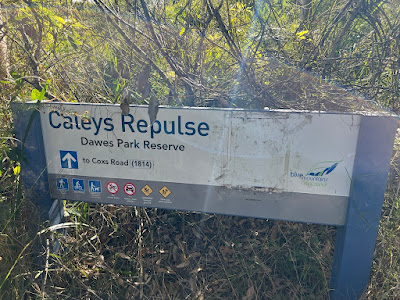
And even better was soon to come. Just beyond Linden's diminutive cluster of houses, the route left the road altogether. climbed briefly onto the ridge line at the strangely named Caleys Repulse...
... and then plunged down towards Paradise Pools:
The track was well maintained and the scenery was gorgeous, particularly after the highway section, but boy it was a long way down. And as the road and rail transport corridor through the mountains follows the ridge, I knew that every step I took down would have to be matched by a step up on the other side of the valley floor.
And it was around here that I started to regret the late start at Warrimoo. As the photo above shows, by now the sun was starting to get lower in the sky and there were two things I was mindful of: not wanting to find myself still in the bush at dusk (I didn't have a head torch with me – note to self: take a head torch, you twit); and the infrequency of trains heading back down the mountains on a Sunday evening.
But in the meantime, I did my best to enjoy the scenery, including this bridge over the creek at the bottom of the valley (at last!) just upstream from Paradise Pools.
The pools themselves would have required a short detour to visit, and because of my concerns about time I decided to save that for another day.
Caleys Repulse was not the only unusual name encountered on this section of the walk. A little beyond the bridge at the bottom of the valley, my route crossed the Transit of Venus Track, offering short detours to a couple of waterfalls.
What, if anything, this has to do with the luminous Shirley Hazzard novel of the same name is a mystery. Neither Mabel nor Edith is a character in that book, as far as I can remember, and the National Parks and Wildlife Service website sheds no light. It does remind me that I mean to reread that masterpiece soon, though.
Sadly, again because of concerns about the time, I decided not to explore these no doubt appealing side tracks.
The walk up out of the valley was a slog, and I had to pause more often than I would have liked to catch my breath, while simultaneously feeling anxious about the gathering gloom. Muttering to myself a reminder that each step took me closer to my goal, I eventually emerged onto a more or less level management track on the ridge line, and soon enough back onto a suburban street, where a tethered goat warily surveyed my passage.
Within 10 minutes I'd arrived at Hazelbrook station, where the platform overpass provided a final view over some of the country I'd just been traversing.
The final hour or so had been tough going. Even the last couple of relatively flat kilometres had been hard work, to an extent that I found slightly depressing given an overall distance of less than 25 km. A closer look at the GPS record provided some comfort, however, as the total elevation gain was 630 metres. I'll face a day in Japan with a similar climb, but spread out over only 16 km. Happily, if all goes to plan the following day will be a rest day. I think I'll need it.


Comments
Post a Comment