Weekend travel to Melbourne for work provided an opportunity for an extra day in the city and a rare chance to explore outside the city centre. The original plan was for a relatively short walk following a route found online, from Camberwell in the east to the city centre, but fair weather and energy to spare prompted an extension to Brunswick in the north.
It's definitely not the most beautiful walk I've ever done, but it's a great example of the variety of built and natural landscapes encountered on a good urban walk. |
| The start, Camberwell. Not my tram |
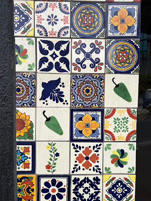
The day began with a 40-minute tram ride from Flinders Street, virtually right outside the hotel, to Camberwell, which was surprisingly quiet on a Sunday morning. Like, I suspect, many people who live outside Melbourne, I picture its suburbs as a more-or-less unbroken string of impossibly cool cafes, punctuated only by an occasional footy oval. The little bit of this suburb that I saw was slightly faded and sad, although I did find this beautiful tile work on a shop frontage:
No coffee, however. So I headed west along Riversdale Road, out of the sleepy shopping zone and into the residential area, glimpses of the CBD towers occasionally visible in the distance. Fortunately, a cluster of shops around an intersection a kilometre or so further on contained a bakery-cafe, which supplied not only flat white but also an amusingly suggestive line of cakes:
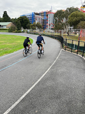
Here the route I was following turned south along Auburn Road, another fairly nondescript residential street, for a kilometre, until a side street led into parklands featuring hockey pitches, the muted roar of a freeway and, unusually, a velodrome.
A little further on a couple more cycles were spotted:
And just beyond that, the freeway, which had been a dull roar and minor irritation behind its high walls, rose on giant concrete legs to stride above the landscape.
 |
| Complex crossings |
For the next couple of kilometres the freeway formed a roof and the soundscape for the path beneath as heavier vehicles thudded over the strips in the roadway overhead. Much of the walking/cycling path was itself elevated over a small creek which, like the path, eventually emerged from under the freeway next to St Kevin's College on the bank of the Yarra. The creek fed the Yarra; the path crossed the larger river and turned left, away from the freeway.
The next few kilometres followed the river towards the city and were very pleasant. One thing that helped was the fact that Melbourne cyclists are generally much more considerate than their Sydney counterparts in ringing their bells as they approach walkers from behind. Other highlights of this stretch included some fine bridges and a family of swans.
Eventually the path passed under Punt Road and reached a stretch of the river I know reasonably well, as I often follow this route on early-morning walks when staying in the city: sports stadiums on the right and the hill of the Botanic Gardens on the far bank.
Past Federation Square and into the bustle of the city at Princes Bridge. By now it was lunchtime, and a Southbank food court supplied a surprisingly tasty bento.
This was the original planned endpoint of the walk, but along the way I'd seen signage indicating that the riverside path I'd been following was part of the longer Capital City Trail, a 29-kilometre route that loops around the CBD to the north – and so I decided to follow it for a long as I could, until I ran out of time or energy.
From Southbank the route continued along the eponymous side of the Yarra past the Crown complex and a series of discount outlets, bars and restaurants.
Back across to the north side of the river via the bridge in the photo above, and past some of the relatively new Docklands development.
The city crowds had disappeared, and it all felt rather empty and unused. Maybe it's different during the week, when nearby offices are occupied.
From there the Capital City Trail turns north, past Docklands Stadium, towards which small groups of Essendon fans were heading in preparation for the game later that afternoon. (Several hours later they would have been retracing their steps well satisfied with the outcome.) Then the route plunged into a tangle of freeways, waste land, construction sites and gangrenous-looking ponds and puddles. It was not pleasant walking, but fortunately didn't last long before offering respite of a sort in the shadow of another vast freeway overpass.
After a while I realised the road above was the Citylink, along which I'd travelled many times to and from the airport. The scale of the difference between driving above and walking below, not only in terms of speed, is startling. In this landscape, all seems organised for the comfort and convenience of the motor vehicles above; humans moving under their own power are grudgingly allowed to scurry, unheard and unseen, and probably up to no good, directly underneath. I imagine only a small fraction of the people using the freeway are even aware there's a walking path below them: I certainly wasn't.
By now the sun was out and the afternoon was warming up. At least the overpass offered a little shade.
After 20 minutes the trail forked right, away from the freeway, and crossed some busy suburban streets into a quieter residential area featuring some lovely old houses and statement ironwork.
Then into Royal Park and the walk's first and only bit of bush. Shade was hard to come by, but I spent a few minutes resting on a bench at the top of a hill enjoying the view north and the relative absence of traffic noise.
Past a golf course and back into Brunswick's suburban streets, I decided to call it a day. The fact a tram stop was nearby helped sway the decision, and 30 minutes later I was back at the hotel.
 |
| The end, Brunswick |


Comments
Post a Comment